Utility AI Mapping: Better Data and Better Decisions with Amir Hofman
Written by
.avif)
Chris Garafola
Published on
April 17, 2025
.avif)

Table of contents
Amir Hofman, VP of Product at 4M Analytics, sat down with me recently for an episode of “Convos with Chris” for a discussion about the latest enhancements to our Utility Object Detection technology.
In this episode, he outlines the time-consuming, costly, and unreliable state of traditional utility mapping and precisely what 4M’s Utility AI Platform as a whole, and specifically our new Utility Object Detection feature, is solving for.
We also dig into his insights about why 4M’s platform is doing more than just gathering data sources in one place: it’s aggregating, analyzing, and iterating to become better all the time. This conversation is packed with can’t-miss knowledge about how, exactly, we’re using the power of AI and innovation to redefine how infrastructure teams plan, design, build and deliver future-proof infrastructure.
Read on for a summary of Amir’s insights, and watch the full episode below.
What is a Utility AI Mapping Platform?
Our Utility AI Platform is a fundamentally new approach to understanding, consuming, and accessing utility data. Traditional utility mapping has relied on fragmented records, outdated as-builts, and manual field investigation. It’s hard to know what’s really out there without exhaustive, inefficient, time-consuming research, and even then there are still unknowns.
So what sets 4M apart as a Utility AI Platform is more than just data. It’s the ability to aggregate, analyze, and enhance utility data at scale using AI and geospatial intelligence.
4M doesn't just collect utility data. We actively process and refine it to create a comprehensive, high-confidence map of underground and above-ground utilities delivered instantly.
And we serve the data within a digital environment that enables teams to validate and interact with the data, and continuously refine the information too. This ensures that the utility data is not just a static dataset. It becomes a living, breathing reliable asset that can be used at every stage of planning, design, and pre-construction.
Eventually, it brings faster project planning, reduced risk of utility strikes, and significant cost savings. Because with better data, better decision-making becomes possible. Watch a quick 2-minute product demo below by 4M's Paul Olenik. 👇
How is 4M's Data Sourced, and How Does it Create the Map?
We take a multi-source, AI-driven approach to data collection at 4M.
Our data pipeline starts by aggregating information from a wide range of sources. These include public and proprietary records, as-builts, GIS data sets, permits, engineering documents, and so on. On top of that, we also use remote sensing, geospatial data, imagery, computer vision, satellite imagery, and aerial imagery to identify surface features and evidence.
That all eventually correlates with the underground utility, and combining that with AI data extraction models that analyze, cross-reference, and validate all these sources to detect inconsistencies and fill the gap.
Once all the raw data is collected, it goes through a structured processing pipeline where the AI-powered engine extracts and standardizes the data, and it validates and cross-checks information to detect inaccuracies and inconsistencies. We also have technology to infer missing data using geospatial analysis and pattern recognition. And eventually we conflate everything and compile it into a final utility map to ensure all the underground and above-ground utility data is structured, connected, and ready to be served instantly.
So unlike traditional methods that rely on manual work, scattered data in inconsistent formats. Our utility mapping product replaces that with instant, high-confidence utility maps—standardized, automated, and always improving.
We’re also continuously collecting new data, new records, permits, engineering documents, remote sensing insights, geospatial data, imagery, etc. and incorporating them into our data, and we’re making sure we’re refreshing many parts of the data on a monthly basis.
Can You Trust 4M's Data?
It’s really hard for infrastructure teams to trust data – they’re skeptical from the beginning. And that’s why trust is at the core of everything we do at 4M. We’re just at the beginning of the journey, and we’re creating a new category and bringing a new product to the construction market.
The primary thing needed is time: the data keeps improving, as does the technology. And organizations will start to use it and get more used to it, and trust will be built.
The next thing to remember is that all industries are undergoing an AI transformation right now, not just construction. And they all have the same trust issue in the AI revolution. We solve this in a few ways.
- First, we cross-validate across multiple sources. We never rely on a single data set. Instead, our AI modules detect these discrepancies and prioritize the most accurate data points from multiple sources. So we’re ensuring we’re bringing our data to the market with as much confidence as possible.
- Second, we internally assign confidence scores for every utility segment in the platform based on the source quality and historical validation. It can never be perfect. But it can be as transparent as possible – it’s something that is evolving continuously.
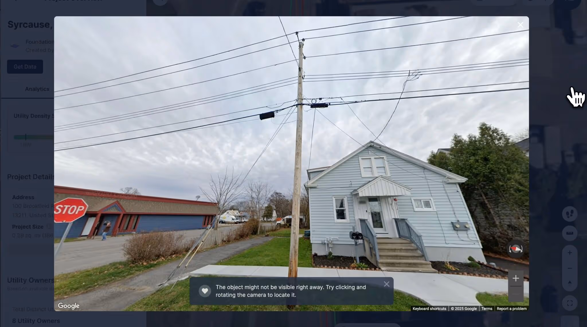
- And on the customer-facing product, we’re providing visual evidence for on-surface objects for all above-ground infrastructure. We deliver real-world references to real-world imagery and visual confirmation to enable our users to cross-reference detected objects with physical evidence.
And we’re also now working on enhancing transparency into the AI-driven decision, which will expose the reasoning behind the utility lines presented on our map. It will give our users deeper insight into how the data was derived, helping them to make more informed decisions and gain more trust in the data.
Another feature we’re working on this year is starting to incorporate a user feedback loop. So our users will be able to interact with the data, validate it against their own data from field investigations, and provide us with insights to enhance accuracy over time.
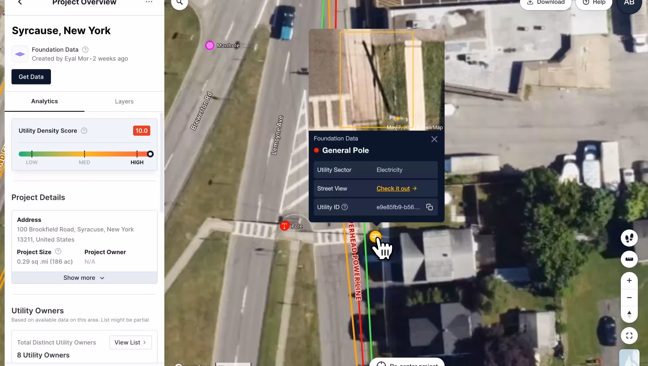
What is 4M's On-Surface Object Detection?
Utility Object detection is an advanced AI-powered capability that enables automated identification and classification of above-ground utility assets. That can be poles, manholes, valves, fire hydrants, pedestals, meters, and so forth.
Traditionally, identifying those above-ground assets requires manual surveys, field visits, and maybe the use of scattered records. It's a process that is time-consuming, inconsistent, and often inaccurate.
Our object detection technology automates this process at scale. We’re using high-resolution imagery and machine learning models to detect, classify, and map critical above-ground infrastructure with precision.
For construction planning, this is a game-changer because it provides engineers and project teams behind the desk or in the fields instant visibility into existing assets. And that’s just the object detection as a standalone.
On top of that, we’re integrating object detection directly into our product along with the utility lines, the attributes, the utility owners, the land ownership, and more good stuff we’re adding. It provides a very comprehensive and reliable data set and understanding of the area of interest of the project, which drastically reduces uncertainty and accelerates decision-making, planning, and more. Watch 45-second product launch video below.
Object Detection lets you:
- Identify: Poles, manholes, valves, hydrants, inlets, and pedestals
- Classify: Instantly distinguish pole types—traffic, electric, or streetlight
- Validate: Confirm objects with time-stamped imagery and Google Street View
- Verify: Deploy field teams with clear targets for on-site confirmation and QA/QC
🤯 And it detects 85% of utility objects with 95% accuracy!
So you can plan smarter, move faster, and reduce field visits across planning, design, and pre-construction.
Watch the 45-second product demo below to see it in action.
What Are the Key Benefits and Use Cases?
✅ Bidding & Pursuits - Quickly identify and verify utility objects without an initial on-site visit to improve cost estimates, reduce unknowns in project proposals, and gain a competitive advantage.
✅ Early Planning & Scoping - Assess existing infrastructure early to proactively and reliably plan for permitting challenges, relocation needs, and any potential conflicts before design begins.
✅ Field Investigation - Utility AI mapping empowers field crews and engineering teams to validate data remotely and cut down on site visits. While they’re not eliminated entirely, it makes the site visits more efficient and accelerates the overall project execution by strengthening QA/QC. Plus, post-field checks are streamlined with remote verification.
Utility AI Platform Vs. Traditional Utility Mapping
A utility AI platform like 4M transforms the utility data that’s currently fragmented and distributed all over from an unreliable bottleneck to an instantly accessible AI-driven asset.
This means that civil engineers, project managers, field crews, utility coordinators, estimators, utility owners – you name it – can plan, design, and build smarter, faster, safer infrastructure.
I hope that 4M is seen as the industry standard for utility intelligence, trusted by all stakeholders. Every engineer, contractor, planner, field investigator, and utility owner will get the foundation for safer, more efficient infrastructure development from 4M.
And beyond just mapping utilities, 4M will reshape how infrastructure projects are planned and executed. This will reduce damage and make construction projects more predictable, sustainable, and cost-effective. If and when we succeed, the communities we serve will benefit from fewer delays, fewer disruptions and a smarter, more resilient infrastructure built environment.
Thanks for the thought-provoking and insightful chat, Amir! Watch the whole interview here.
Key Moments Transcript
What is a Utility AI Platform Vs Traditional Utility Mapping
Amir Hofman: "A Utility AI platform is a fundamentally new approach to understanding, consuming, and accessing utility data. If you look at the traditional way. So, traditional utility. Traditional and still ongoing. Utility mapping has relied on fragmented records. Outdated as-builts. Manual field investigation. And you can continue that to more things. Usually resulting with uncertainty. Delays. And costly mistakes at the entire project lifecycle. So what sets Utility AI platform apart is its ability to aggregate. Analyze. And enhance utility data at scale using AI and geospatial intelligence. We don't just collect data, right? At 4M Analytics. The game is not just to collect data. We actively process and refine it to create a comprehensive, high-confidence map of underground and above-ground utilities delivered instantly, right? And designed to fit any workflow. In the AI platform, you have two components. Or Utility AI platform. You have the AI component, which is the technology. But, also, plus to that, the domain expertise is the key. So when you're combining both, you can create something that creates impact. That's the data aspect.
But beyond just providing data. Our platform, we serve it within a digital environment that enables teams to validate. Interact with the data. And continuously refine the information, right? Eventually, this ensures that utility data is not just a static dataset. It becomes a living, breathing reliable asset that can be utilized across different stages of the project life cycle. Eventually, as a result, it brings faster project planning. Reduced risk of utility strikes. And significant cost savings. Because with better data, better decision-making becomes possible. Definitely, if you get the data at the early stage of the project."
Why should you trust 4M’s utility data?
Amir Hofman: "This is very significant topic. And trust is at the core of everything that we do. We're just at the beginning of the journey, right? We are creating a new category. We are bringing a new product to the construction market. And time is an essence. I mean, eventually, the data will get improved. An organization will start to use it and will get more used to it and trust will be built. Second thing is that within the entire AI transformation or revolution. Within all the industries, all have the same trust issue. How are you reasoning an AI answer? How you are providing a reasoning or a reason to something that was produced by AI? It's not just a problem for 4M in the construction industry. It's a challenge for all the AI revolution across industries.
Now, I'll speak more about what specifically we do. First of all, we are cross-validating multiple sources. We never rely on a single data set. So instead, our AI modules detect these descrepencies and prioritize the most accurate data points from multiple sources. So we're crossing them and making sure that we're bringing our data with high confidence as possible to the market. Second point, internally we are assigning confidence scores. So every utility segment in our platform has a confidence level based on the source quality. Quality. Consistency. And historical validation. It can never be perfect. But it's something that is evolving and helping us to provide more reliable data.
On the customer-facing product, we are providing visual evidence for on-surface objects. For all the above ground infrastructure. We deliver real-world reference to real-world imagery and visual confirmation to enable our users to cross-reference-detected objects with physical evidence. And now we are also working on, and hopefully it will start to be available very soon, on enhancing transparency into the AI-driven decision. Something that we are already actively working on—this new capability that will expose the reasoning behind the utility lines presented on our map. It will never be full reasoning with all the options. But it can bring some reasoning to our users so they will be able to correlate and to reference our data and understand why we provided it to them. It will give our users deeper insight into how the data was derived. Helping them to make more informed decision and gain trust in the data. Another initiative that we would like to cover this year is to start to incorporate feedback loops. User feedback loops. So our users will be able to interact with the data. Validate it against their data or field investigation data. And provide us insight to enhance accuracy over time. Again, something that we plan to incorporate in the product later this year."
Chris Garafola: "That's really exciting. And you mentioned earlier earlier too that other industries are all facing the same AI digital transformation. I don't want to say problem, but question. How can we trust this? And I forget who coined this. I heard this the other day about don't let perfect be the enemy of progress. Because it's still progress. It's still better than what we had. And we should embrace that as an industry."
Amir Hofman: "Exactly. Right. I'm using, for example, ChatGPT or similar tools on a daily basis and I'm just increasing my usage. It doesn't give me the perfect answer. I don't copy and paste it and send it. Right. I copy it and then I revise it. And then I review it. But why I'm using it? Because it gives me a tremendous jumpstart."
Chris Garafola: "Yeah. Right, that speed to value. You're getting to the finish line quicker. Whatever percentage you want to say, whether it's 30 % faster or 40. It's faster."
Amir Hofman: "Yeah. It's faster and it's getting better. The same here. Right. Month over month, our data is getting better. So we are moving at a speed of whatever. A spaceship. And the data is getting better and better."
What is your product vision for 4M?
Amir Hofman: "I hope that we, 4M. Is seen as the industry standard for utility intelligence trusted by all stakeholders. Every engineer. Contractor. Planner. Field investigator. Locator. Whatever. Utility owner. Will get from 4M the foundation for safer, more efficient infrastructure development. And beyond just mapping utility, 4M will reshape how infrastructure projects are planned and executed. Eliminate uncertainty. Reducing damage, and making the construction projects more predictable, sustainable, and cost effective. If and when we will succeed. The communities we serve will benefit from fewer delays. Fewer disruption. And a smarter, more resilient infrastructure and built environment. That's the plan. The train has already left the station. You choose. You jump on it or you stay behind. Yeah, I'd rather be on it instead of having to jump on it. That sounds a little dangerous."
Chris Garafola
Brand and Content Leader
With over a decade of experience spanning agencies and innovative startups, Chris is a dedicated content marketing leader, driven by the belief that content isn't just about consumption; it's about leaving a lasting impact on the person who engages with it.
Inspired by 4M's mission to create the first online database of subsurface utilities in the U.S., Chris is eager to illuminate one of the infrastructure industry's most pressing issues and champion innovative solutions that deeply resonate with general contractors and civil engineers to address these challenges.
Recent blog posts
Here's What's New in 4M: August 2025
August brought a powerful new way to give teams flexibility and control with the ability to update utility line attributes in real time. The result? A more dynamic 4M—built to help you plan smarter and push projects forward with confidence. Plus, we launched Foundation Data in Oklahoma!
Chris Garafola
September 2, 2025

Transforming Infrastructure with Advanced Utility Data
Increasing costs on materials and components, rising overheads, compressed timelines, and higher competition for bids—the construction industry has little room for error when it comes to maintaining owner cost-benefit and contractor profitability. Any source of uncertainty must be assessed, quantified, and mitigated to ensure successful outcomes. So why does the number one risk factor for transportation construction projects often go unacknowledged?

Tamar Shafrir
August 21, 2025

Texas Utility Environmental Risk Report
Underground utility infrastructure plays a critical role in Texas’s environmental and public health efforts. Yet, despite its scale, spanning more than 1.4 million miles statewide, much of this infrastructure remains unmapped or poorly documented. This lack of visibility and incomplete asset management creates challenges for environmental risk management and compliance with evolving regulations. This is especially relevant in the case of utility lines made from high-risk materials that may be prone to failure and corrosion, or harmful to human and ecological health.
August 21, 2025

Maximizing Underground Design Efficiency Now and in the Future
The United States is embarking on a massive infrastructure build out to support as much as $10 trillion of new investments. Even if just 50% of that total is achieved, that’s still a significant amount of investment.

Mike Beehler
August 21, 2025
Here's What's New in 4M: July 2025
July turned up the dial on clarity, control, and efficiency—with new tools that give Admins clearer visibility into project usage, expanded detection of on-surface assets like meters and control boxes, and statewide Foundation Data in Illinois to make your day-to-day more efficient, more strategic, and a whole lot less manual.
Chris Garafola
August 4, 2025
Our Newsletter
Join 7k infrastructure professionals
Get monthly insights on ways to build smarter, faster and safer with Utility AI.